Thursday, December 4, 2014

High Sierra Trail Part 3 - Big Hamilton Lake To Big Arroyo Junction

Day 3 : Big Hamilton Lake To Big Arroyo Junction - 6.5 miles; 1,320 feet elevation gain


The sun shines today! Finally.


And it's Precipice Lake Day! The lake that started me planning this trip shenanigan that we embarked on. And we'll be climbing 3 miles and 2,000 feet for it.

We had plans of setting out early today so we can take a leisurely break at the lake, but got held at breakfast talking it up with one of the many very interesting hikers we would meet on this trip. And it is true, those whispers about the outdoor community, that we all can talk... a LOT.

We laughed, shared stories, backcountry finds, talks of home adventures with her. This was our first day getting sucked in the El Vortex, as we have dubbed the situation. Eventually, we would come to find out that it was hard to resist getting vacuumed into it.

Taking advantage of the El Vortex though, we actually got to properly dry our tents and other stuff that had been wet ever since we started the trip. They were all gloriously laid out in the open and letting the sun take all the moisture away.


We bid adieu to our beautiful spot at Hamilton Lake. The trail continues on other side of Hamilton Creek and starts to climb up the exposed trail, where we saw the boy scout troop disappear to earlier that morning. Watching them over breakfast gave us an idea how high we were going to be for the first leg of the day's trip, mentally preparing us.


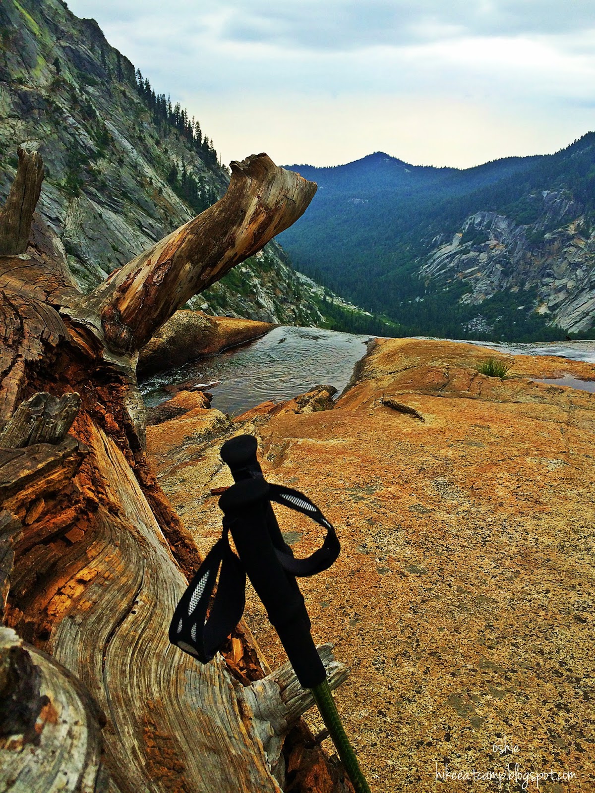
Not even a mile in, our previous campsite seemed so far away already. We can spot it way down below us. After a few long and short switchbacks, the trail continues on and in one turn, reveals just how much effort was put into creating this trail. The Hamilton Gorge Tunnel was of amazing work. Kudos to the trail engineers and crews!


Passing through the tunnel, the trail bends into a form of a horseshoe, and continues on, crossing a waterfall. This cascade of water must be a sight to see (and cross) after a good wet winter season would pass and would have a good amount of snow melt cascading down the slope.


After about a mile or less, there's a body of water pretending to be the infamous Precipice Lake. But don't fooled by this impostor of beauty! Just kidding. Although it is truly not Precipice Lake just yet, it is still a beautiful lake. Well, all lakes are beautiful in my book, anyways. And although, it looks like it is a good spot to stop and take a break, the lake made famous by photographer Ansel Adams, is  just close by. We only stopped here long enough to take a few goofy photos and gaze up where boulders are hiding our targeted lunch spot for the day.

We climbed a few feet more and could see the granite wall that I know is the backdrop of the lake I've been day dreaming about since.. forever. It was a tease. So close, yet so far was on repeat on my mind to prod my feet to keep on moving.


The first glimpse of water I saw, I ran the rest of the trail that remains between me and the lake. Found a good spot away a little off the trail and closer to the water. Unceremoniously dropped my pack and didn't care what the rest of the day will bring at this point. In my mind, I have arrived. 10,200 feet from sea level and away from civilization, I am at Precipice Lake.


We had a leisurely stop here for lunch, naps and some photo overload. The colors on the lake were constantly changing as the sun started to play hide and seek among the clouds. We would have stayed longer if the clouds didn't didn't completely decided to hide the sun from us. And thick clouds then started to cover the peaks above. Wind started to pick up a bit, as well, so we unwillingly collected our lunch spread, filtered more water and hopped our way back on the trail. It was still a 400 feet climb to Kaweah Gap with a very short distance to hike before we can start our 1,300 feet descent.
Most of the climb was at the start and once we lost sight of the now gloomy looking Precipice Lake, the trail became more forgiving on our legs. We passed a couple of lakes before finding ourselves on Kawaeah Gap.


 The view of the Nine Lakes Basis was so grandeur standing at the base of Mount Stewart on Kaweah Gap. A plaque for Col. George W. Stewart, named as the "Father of Sequoia National Park" was placed here by the National Park Service in his honor.


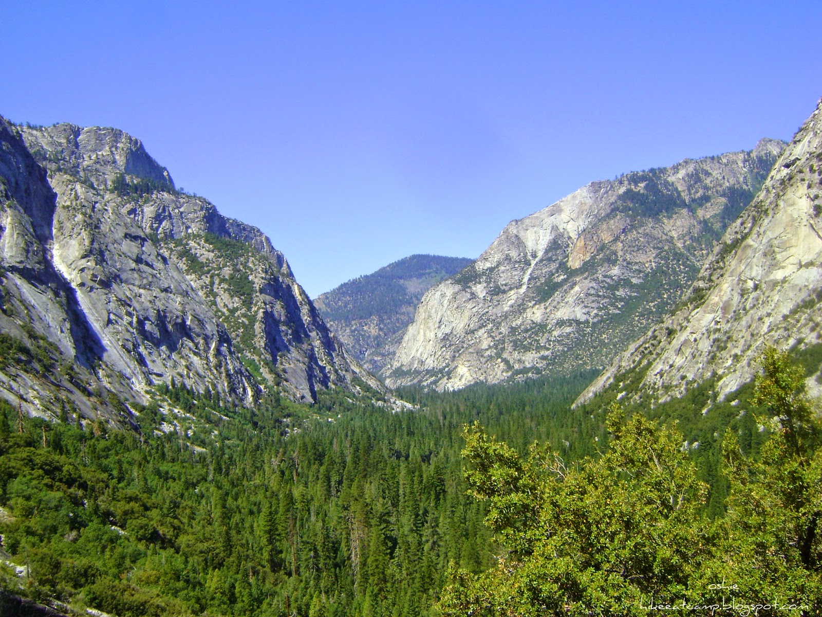
The trail continues along a few switchbacks, descending on to the valley, a grand open space with the Big Arroyo running in the middle of it. Descending, I felt like we were in a cartoon of dog-cat-mouse chase. We found ourselves chasing the blue skies just ahead of us while dark ominous clouds were not that far behind us, nipping at our heels.


The trail eventually flattens and follows the river downstream most of the way, then eventually crossing it and continuing on through to enter a thickening wooded area. Water level was low at the crossing but as expected, freezing.


The trail splits with the right fork directing to the Big Arroyo Patrol Cabin and the left fork continuing on the High Sierra Trail. Leaving the left fork for tomorrow's journey, we made our way to our home for the night.


Several camp sites can be found just beyond the Big Arroyo Patrol Cabin. There are food lockers in this area. And for the hammock campers, lots of trees to hang your bed for the night. We waved to a few campers we've met and leaped-frogged along the trail, and found a cushion-y spot to pitch our tents. Mosquitoes have not been a problem since we started this trip. Probably due to the dry winter we've previously had. With that in mind, we still had a good number of mosquitoes pestering us here. I can only imagine what's it like during a normal season, in the beginning of August.

Thursday, November 13, 2014

High Sierra Trail Part 2 - Buck Creek Crossing to Big Hamilton Lake

Day 2 Buck Creek Crossing to Big Hamilton Lake - 6 miles; 980 ft elevation gain


Short mileage day today!

We awoke this morning to sounds of a few early hikers trudging along the trail, just a bit above our camp. By breakfast, more hikers were hiking by. Waved and raised our coffee cups to them in greeting. Some we recognized from meeting the day before and had camped out at Nine Mile Creek.

Given that we pushed those extra miles yesterday, today was going to be a short one for us.. 6 miles! We were not at all in a hurry. We savored breakfast before taking down camp. Our camp neighbors, who were using this spot as a base camp, have already gone to do some exploring.

The sky was still overcast by the time we were leaving, still no sign of some sunshine! Packs on our backs, we did a final sweep of our camp, making sure no gear nor trash got left behind. Gotta practice those ninja skills and leave nothing behind to incriminate that we were ever there!


Hopped back on the trail. We crossed Buck Creek on a wooden bridge.. more like a platform, really. Then the trail just immediately started going straight up ascending to take us out of Buck Canyon! Talk about a warm up! That woke me up more than coffee!


After climbing about a couple of steep switchbacks, the trail lets up to a gradual climb before eventually flattening and then we found ourselves surrounded by trees.

A mile and some 600 feet higher later, we started smelling something baking - oh it was pure torture knowing we can't stay and have some of those fresh baked goods! We have arrived at the Bearpaw Campground, the High Sierra Camp of Sequoia National Park located at 7,820 feet. A place for glamping at its finest. Trust.


A little description of Bearpaw High Sierra Camp and its difference from its sister high sierra camps over at Yosemite (an information of what I've gathered ever since I started eyeing this place):

Straight on, past the ranger station (right) the HST continues.
  • Bearpaw High Sierra Camp has 6 tent cabins, equipped with a couple of twin beds with bedding, too!
  • Included in your stay are your breakfast and dinner meals served family-style - lunches and alcoholic beverages purchased separately.
  • Staying here needs an advance reservation. While unlike the high sierra camps at Yosemite, you do not need to enter any lottery in hopes of getting picked to be able to make that reservation.
  • Also unlike it's sister high sierra, when there's just 2 of you staying, you don't get to be paired with other people to share a tent cabin with. You book it, it's yours and yours alone.But note that lodging is limited to 6 tents, chances are availability is hard to come by so best be ready when reservations start becoming available for the next season.
  • And as of 2014 price is at $175 per night, per person - totally, not cheap.
If I ever get to becoming old, retired and/or filthy rich, apart from my regular backpacking, I'd stay there every summer for at least a week and not worry about anything else but getting myself there and bringing clothes and books to read! I'll stroll that 11.5 miles all day with practically almost nothing on my back. Oh to dream.

But I digress.

Back on the current adventure!

We stopped for a bit here as the views by the main hall were spectacular, even with low clouds rolling and still overcast. We had a quick chat with a some folks who were staying at the High Sierra Camp. We got forewarned of a bear in the direction we were headed.

A few quick pictures here and there and we were back on the trail. We didn't get to see that bear though, much to Joe and Ryan's disappointment. They were on a sub-mission to see a bear in the backcountry on this trip.

One thing this trip is never going to be short on.. are the VIEWS! (Yes, in all caps.) Amidst the clouds, the Great Western Divide will be watching us as we trek along to our next destination: Hamilton Lakes. And down below us is Middle Fork Kaweah River, which can barely be seen, probably a combination of the low clouds, mist and this year's drought that the water is not flowing well or maybe we're just too high up or maybe 'cause I'm far-sighted - I'll go for the latter.


The trail continues along the ridge before it starts to descend to about 400 feet to cross Lone Pine Creek. On our hike down, wincing on my bothersome right knee ( minor injury from a recent face plant, kiss-the-ground-while-you-are-down-there fall on a previous trip), I still practically ran the rest of the way down as soon as I saw the first glimpse of a bridge.

I think bridges are amazing! And even more amazing are backcountry bridges. It's in the middle of nowhere! Lugging the materials alone must have been a chore on its own. Then you still gotta build it! A couple of hikers, who we saw taking a quick rest at Bearpaw, had their camp chairs popped up and were having their lunch break on the other side of the bridge. Yup, they sure had their lunch with a view!


We dilly-dallied for a bit, looking over one side of the bridge.. then the other. Taking pictures. Prolonging to deal with the inevitable climb we still have to slog through before we can properly prop our feet up and relax the rest of the day away. Below the bridge, we saw traces of probably remnants of the befallen old steel bridge that was once used to cross here.


We continued on, as the bridge, now behind us, started looking smaller and smaller as we climbed up. We did a quick rest stop at the Tamarack Lake junction to shed some layers. Blue sky started appearing but it was short-lived. As we kept climbing up, thick clouds started covering up the sky again (bye bye blue!). I kept looking up watching, observing. We were keeping attentive in case we need to haul it out there. We were on an exposed environment, did not want to get caught out there if thunder and lightning decide to party it out.


Following the very well maintained trail, we eventually found our way atop the Hamilton Creek waterfall we've been admiring from afar. And got to see a little ways below from where we had come from. We could actually make out the trail that led us down to the bridge at Lone Pine Creek from where we were standing.


One of us finally put a halt on our goofing around, so we continued on. But just before leaving the top of the falls, we came across our former camp neighbors from Buck Creek. They were already on their way back from Hamilton Lakes.

The trail continued on up till we came up to a sign that indicated we were finally at Hamilton Lakes. A few feet beyond the sign is a spur trail turning right and leading to one of the best viewed outhouses I've seen. I could sit there all day.. but I'd probably need to breathe at some point. It's a pit toilet. And guessing the amount of visitors this area gets.. yeah, I'll leave it at that.

The lake and campsites are further down to the left of the trail, past the spur trail to the pit toilet. There are 3 food lockers in the vicinity. The largest one is right close to the trail going towards the lake There is one closer by the lake, in the middle of a big clearing. The other by a few camp spots above the lake.


Joe was the first to get there. When the rest of us followed, we saw a large group of boy scouts already set-up amongst other campers who are also already set-up. Sites were plenty, but so were campers. We did get advised it was a popular spot. And looking around, we understand why. It had all the perfect formula of a good camp spot: a beautiful lake, flat spots, boulders strewn around, trees, and a clear, unobstructed view of the sky.


In our quest to find us a better spot to camp, away from the big boy scout group, we found a few cozy places perfect for one or two people, above and a little bit further from the lake than we'd like. Though we couldn't utilize it ourselves, we were able to pass it on to other smaller group of hikers.


That evening, we were blessed with clear skies. And with the generosity of other campers with their information, we were able to observe the International Space Station float across directly above us. That was a pretty cool experience! I totally geek-ed out on that one, Not a science nerd myself, just a little human being always easily amazed by amazing things.

Our only decent photo of the International Space Station passing by.

Wednesday, November 5, 2014

High Sierra Trail Part 1 - Lodgepole Campground, Wolverton to Buck Creek Crossing

Day Zero: Los Angeles, CA to Lodgepole Campground, Sequoia National Park: 225 miles (drive) - 6,467 feet elevation gain


Saturday morning, we all met up at my cousin Chris', who was dropping us off at the Sequoia NP side of our trip. Czarina coming from Northern CA, already spent the night there. Joe, who arrived the previous night from Las Vegas, and I were dropped off by Kari. And Ryan, who was also coming from SGV (like me!), also got dropped off. The Quartet have converged!

We left Los Angeles at 9:00 a.m., with the intention of leaving at 7 a.m. I blame my weak resistance to my uncle's usual Saturday breakfast spread of eggs, garlic fried rice and bacon! (nom). We loaded up Chris' car, bid Kari goodbye, and left her our itinerary for the entire week for safety, since she's the one who'll be picking us up a week later at Whitney Portal (I always love our reunions when I adventure sans her, days of missing her is a sight for sore eyes!).


The drive up to Sequoia National Park was, as always, beautiful. No matter how many times I have made this travel up to the park (Trivia: it's our favorite National Park!), I never tire of this journey. The change from busy L.A. traffic with views of concrete buildings, to views of endless farmlands, then to the hills and mountains that loom closer and closer, and then the views of the valley down below as you continue the drive up to the park. It always still amazes me.

After a not-so-quick lunch at The Corner Cafe in Visalia (awesome diner food if you're in the area, by the way!) and a stop by the Giant Forest area in the park, where we saw a bear roaming around the lower parking lot, we arrived at the Lodgepole campground and opted to pick up a box of pizza at the Lodgepole Market to bring over to our campsite for dinner, while we do pack shakedowns.

Pizza Pack Shakedown.. but first a pic!
The starting cast (from upper right): Me, Ryan, Joe, Czarina,
and featuring: Chris.
At camp, we set-up the tent that we were all going to be squishing in to for the night and then undid all the packing we each did at our respective homes. Surveyed our packs' previous contents and each other's, deciding what needs to be left behind and if we missed to consolidate anything. By dusk, we've all repacked our backpacks and happy with all our starting  pack weights for tomorrow. Joe, I think, was the happiest, he shed almost 10 lbs from his pack! Which enabled him to borrow Chris' camp chair and for which he was grateful to have had on the trail!

Done with re-packing, we gathered up some wood for a campfire and huddled around for a bit before calling it an early night. Early day the next day, permit pick up at 7:00 a.m. at the Visitor Center, and us girls were determined to have one last shower with indoor plumbing at the Lodgepole Market.

Day 1: Wolverton Trailhead to Buck Creek Crossing: 10 miles - 100 feet elevation loss


We awoke to a light drizzle at our campsite Sunday morning (jump off day!) but no rain, drizzle or wet ground was going to damper us on this day, Day 1 of our High Sierra Trail adventure!

We were promptly at the wilderness desk by 7:00 a.m. and already there was a small crowd gathered, picking up permits for various trails. The permit issuer noticed the small crowd and decided to grab everyone's attention and did the mandatory review of park backcountry rules altogether (smart move on her part! Otherwise she'd be like a broken record for the next 20 mins).

No rain. No heat. No hail. No sleet.
Shall keep these hikers off their feet!
- inspired by the postman's creed
After receiving our permit, the guys had gone ahead to grab breakfast and us girls went straight to the shower room armed with quarters before catching with them for breakfast. Showered and bellies full with breakfast burritos, we took the short drive to our trailhead at Wolverton, the alternate starting point for the High Sierra Trail. The Lake/Alta Trail from Wolverton connects with the High Sierra Trail at almost the same distance as starting at Crescent Meadow.

The drizzle started to come down harder (but not a downpour just yet!), as soon as Chris put the car on park. Mother Nature wanted to send us off to a wet start! After some obligatory, not-so-pretty, getting-drenched-now, "before photos", we said goodbye to Chris, gave last minute directions going home, and thanked him profusely. And off we go to have a wet 'n wild day!

On the Lakes Trail, we met a few hikers heading out. We all bid each other quick hello's and happy trail wishes, couldn't stop for a chat lest we get ourselves more wet. In theory, figured movement can keep us from getting soaked. Might be true, considering the sooner we get to camp, the sooner we can get sheltered!


At about a mile and a half, we hit the trail junction, with the left fork continuing on the Lakes Trail to lakes Heather, Aster (both no camping), Emerald and Pear. We took the right fork in the direction of Alta Peak that meets up with the High Sierra Trail. We came across a couple of "hoppable" downed trees on the trail, and after a steep last stretch, arrived at beautiful Panther's Gap. The sun was still not showing herself and the clouds were flying low, but still Panther's Gap has an awe inspiring view (Note to self: Come back on this spot, on a blue bird.)


We will be graced with this incredible view for majority of this day's hike. A mile more to go to the Alta Peak junction. Then 2.2 miles more to Mehrten Creek that'll get us on the High Sierra Trail. The rain had let up a bit, though the air was still damp, still lots of moisture.

Alta Peak and Mehrten Creek Junction
The trees have started getting thicker, we eventually found ourselves at the Mehrten Creek junction. We're now, finally, on the High Sierra Trail! We still had 2 miles from this point to get to our destination for the day: Nine Mile Creek, where there's a standard sized bear box.


Low rolling clouds accompanied and entertained us along the trail. They were like curtains teasing us, giving us sneak peeks of the valley below us. I could easily just sit on a cliff's edge and get lost watching the clouds roll in.. thicken.. cover a peak then roll back and reveal what it hid. Find the inner kid in us and play a game of peek-a-boo with nature.


Arriving at Nine Mile Creek, some of the hikers we met along the trail have either, already settled in or are settling in and pitching camp. It appeared to be a small area and already getting filled up. We debated and considered that we still have enough sunlight left to push on 2 more miles, but the ranger also mentioned that Buck Creek Crossing was also a small camp area. We took our chances armed with the thought that we'll have 2 miles less to hike for Day 2.


As the trail started going steeply downward, down below, we caught a glimpse of a large bear box, 2 small tents pitched up close by and Joe (who went ahead of us) waving frantically, looking ready to scream "Land ho!". We finally arrived at our first camp site for the week, Buck Creek Crossing! With still enough day light (though overcast!) to set up camp, have dinner, clean up and water prep for the morning. Caffeinated hikers in the morning is a primary mission to start the day.

Coming down to Buck Creek Crossing. Spot us?
Buck Creek Crossing has 4 camp sites. We didn't see any markers to indicate each sites, but the clearings are evident. There are 3 small ones close to the shared large bear box. Each with space for one 2-3 person tent, cozy if you pitch two. And 1 large space when you round the corner after the 3rd site, enough to fit 2 tents comfortably, 3 if you don't mind being cozy. Too tired and eager to get on dry clothing to be picky, we settled on the 3rd space and ended up pitching 2 of our group's 3 tents for our first day. Confession: we only found the bigger, 4th space after the tents were already up. Womp womp womp.


There is a community fire pit by sites 1 and 2, like what the ranger who gave us our permit mentioned. But we did find a fire ring on the bigger camp space, though it look to be more "camper made".

After dinner, we stayed out longer campfire-less, talking, re-capping the day's events and the people we've met, some who were also doing the High Sierra Trail like us and wondered if we'll cross paths with them again since we're slow hikers, generous photo takers, major time wasters in gazing around, big chit-chatters and generally cannot eat trail food while in motion.

Tuesday, September 23, 2014

Rae Lakes Loop - Kings Canyon National Park

Within the rugged back country of majestic Kings Canyon National Park, lies a beautiful 46 mile hike popularly known as the Rae Lakes Loop.


This hike has been on my ever-growing to-do list, since I ever started one. I have applied, gotten approved and cancelled a permit a couple of times due to various reasons before finally being able to complete it and then repeated. Because it's such a beautiful hike, I'd still do it all over again! The first trip was my doing and the second was an invite, and on both occasions doing the same direction and same length of days.

The loop can be done by either a clockwise direction or a counter clockwise, which I think both have its merits. I haven't completed a counter clockwise of this hike, but have hiked up to a certain point in that direction and camped at about 8 miles in.

The itinerary posted below will feature the more popular clockwise route.

Even though the trail is described as a loop, it is more of a "lollipop" kind of route. It still starts and ends at the same point, but the full circle meets with another 2 more miles to the trail head.

This hike can be done in lengths dependent on your preference of what you'd like out of the trip. I've heard of hikers doing this loop in 24 hours, some have done as an overnight. But for a more leisurely pace, 5 days is just about right and 7 days is luxurious. We had more than enough days to soak in everything with both our 7 day trips.

I'll be posting a chart below to summarize our daily mileage and elevation loss and gains with information to help plans yours!


Permit


The clockwise route, via Woods Creek Trail, is the more popular route due to the elevation you'll gain is somewhat easier than the counter clockwise route. To give a visual, on your first 8 mile hike via the clockwise route, you'd have gained about 1,600 feet of elevation. Whereas, doing the counter clockwise route, via Bubbs Creek Trail, your first 8 miles gains you about 2,225 feet elevation.

Given its popularity and if doing this hike during the peak, quota period, I strongly recommend submitting your permit applications very well in advance. I'm a stickler for this and send applications on the first day the park service opens their calendars for reservations, which is usually th 1st day of March. There are no phone reservations nor online (yet), all are required to submit via fax or mail.

I mail. I love old school mail and I love stamps!

Here's a link for a copy of the permit: Wilderness Permit Application. Please read the instructions carefully and make sure to fill out your other choices of entry dates (or places, if you prefer), in case the first doesn't pan out.

Weather


Here's a link to NOAA's website, pinpointed on the area at the start of the loop trail. Pan the map on the right hand side to get an updated weather report on a specific area of the loop.


Food Storage


Bear canisters are required in this area. Bring them if you already own one or rent one from several places, like your local REI store, Bearikade rents their product through their website, or you can also rent one from the Road's End permit station.

On hindsight, I should have rented one from the permit station and left my Garcia. From observation, I think the permit station rents out the ever so light Bearikade!

Although there are available bear/food lockers located by the popular places camp sites to use, these lockers should not always be relied upon. They can get filled up fast for several reasons, and especially on areas with high foot traffic and along the trail where thru-hikers pass.


Getting there


Kings Canyon National Park is in central California. The entrance can be accessed via the CA SR-180 in Fresno, CA. If you do not have a National Parks Annual (or Senior) Pass, the entrance fee to the park is $20 for one vehicle (all passengers included) or $5 per person on foot/bike, and it's valid for 7 days.

Head on straight past the entrance and take the left fork on the road when you get to the "Y". Drive straight along the 180/General's Highway and enjoy the 45 minute scenic drive to Roads End.

There are several camp grounds along the route if you'd like to arrive a day or 2 before your jump off day to acclimate especially if you're coming from sea level (like us!). And some camp grounds have coin operated shower facilities (get those quarters ready!) for those who'd like to have a last shower before giving up indoor plumbing for a few days.


Our itinerary


POINT/ LOCATIONELEVATION [IN FEET]MILES FROM ROADS ENDELEV FROM LAST POINTMILEAGE FROM LAST POINTNOTES
TH - Road's End5,0350.0
Paradise/ Bubbs Creek Junction5,0352.0
Mist Falls5,6634.0No camping
Lower Paradise Valley6,6006.0Standard bear box
Middle Paradise Valley6,6318.01,5968.0Standard bear box
Upper Paradise Valley6,91611.0Large + Standard bear box
Castle Dome Meadow8,173
Woods Creek Crossing8,50017.01,5849.0Standard bear box
Dollar Lake/ Arrowhead Lake10,30022.0Standard bear box @ Arrowhead
Lower Rae Lake10,538
Rae Lakes10,59625.02,0968.0Large + Standard bear box
Glen Pass11,97827.5
Charlotte Lake Junction10,61930.0
Vidette Meadow9,62932.0Standard bear box
Lower Vidette Meadow9,482
Junction Meadow8,15635.0Standard bear box
Charlotte Creek7,26038.5-4,71813.5Standard bear box
Sphinx Creek Junction6,31642.0Standard bear box
Paradise/ Bubbs Creek Junction5,03544.0
TH - Road's End5,03546.0-2,2257.5